Nationalpark Gravel-Tour Etappe 2: Val Müstair – Livigno
Medium
36.3 km
5:00 h
1077 mhd
902 mhd
Technique 2/6
Fitness 4/6
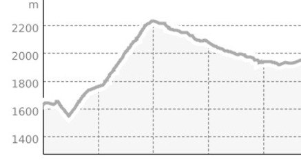
Highest Point  2295 m
Lowest Point  1550 m
Best Season
Jan
Feb
Mär
Apr
Mai
Jun
Jul
Aug
Sep
Okt
Nov
Dez

Details

Description

The second stage of the "National Park Region" e-mountain bike tour leads down the valley to the entrance to Val Vau. On the first long climb towards Döss Radod, the forest dominates the landscape. The fascinating rock face with the waterfall as an outlet of the Lai da Rim in the south makes the ascent through the Val Vau an entertaining and attractive section. From Döss Radond you are in the very extensive, wild Val Mora and enjoy the relaxed continuation to the alp of the same name, before the subsequent trail to Lago San Giacomo di Fraéle demands full concentration, because on the way there there are always slightly exposed places. The forces of nature are strongly evident in this region in the erosion and the loose subsoil of certain passages - depending on the nature of the path, short carrying passages are possible. After a loop around the lake and over the dam, the path continues towards Alpisella, the second pass of this tour. A break at the pass compensates for the exertions of the ascent as well as the subsequent descent to Lago di Livigno.

Sicherheitshinweis

On high-altitude sections, snowfields are possible until the summer months.

The tour was evaluated in favorable weather conditions, the current weather conditions and weather forecasts must be observed before the start of the tour. This tour does not place any special demands on driving safety and technical skills.

Emergency call:

144 Emergency, First Aid1414 Mountain Rescue REGA112 International Emergency

Be considerate when crossing and overtaking hikers.

The Graubünden mountain bike routes run largely on single trails, which are also signposted as hiking trails. Hikers always have the right of way.

Ausrüstung

Helmet, gloves, good footwear, glasses, rain and sun protection, water bottle, repair kit, bandages

Directions

On the right side of the Val Müstairs valley to the entrance to Val Vau. From here, the trail climbs steadily through the Val Vau on wide forest roads to the first crossing at Döss Radond (2234 m) and continues through the Val Mora. From Alp Mora (2220 m), a challenging single trail leads through Legföhren to Passo Val Mora (1952 m). After Lago San Giacomo di Fraéle (1949 m), the ascent to Alpisella (2299 m) follows. Then on a well-developed unpaved road steeply down to the Lago di Livigno reservoir and to the stage finish in Livigno (1810 m).

Directions

Public Transport

With the Rhaetian Railway (from Chur, Landquart/Prättigau or from the Upper Engadine) hourly to Zernez

Take the PostBus (from Zernez or Mals) every hour to the PostBus stop Fuldera, Furom.

Anreise Information

From the north: via Landquart - Klosters by car transport through the Vereina tunnel (Selfranga - Sagliains) or over the Flüela Pass to Zernez on H27. From Zernez on the H28 into Val Müstair to Fuldera. (35 minutes drive from Vereina south portal)

From the east: via Reschenpass (Nauders) on the SS40 to Mals. From Mals on the SS41 to the Swiss border to Müstair. From Müstair on the H28 to Fuldera.

From the south: Via Bolzano and Merano on the SS40 to Mals. From Mals on the SS41 to the Swiss border to Müstair. From Müstair on the H28 to Fuldera.

Parken

Free parking in Fuldera.

Responsible for this content Tourism Engadin Scuol Samnaun Val Müstair AG.
This content has been translated automatically.

Outdooractive Logo

This website uses technology and content from the Outdooractive platform.